

25 + 20 points
Water Map by Cameron
July 11th, 2006 12:23 AM
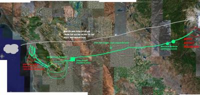
Drinking water is something this city has in spades. I knew it came from the Hetch Hetchy Resevoir, but I learned a lot in researching the path it takes.
The reservoir is filled naturally by rains and melting snowpack, which start at the Ocean and travel inland.
After a long wait in the rervoirs, it passes through numerous smaller ones, over dams at power stations, and through the Sunol Valley Treatement Plant. Most of The distance is through aging pipelines deep underground through the San Juaquin Valley.
It is waylaid in a few reservoirs south of the city, and goes through another processing, before being dutifully piped to our sinks and showers.
I left some of the numerous substaions and forked paths off, as they did not directly deal with San Francisco; but there is still plenty more to add, if someone feels so inclined.
Special thanks to Google Earth, and the indomitable MS Paint.
Raise a tall tasty glass to the best urban drinking water around, and peruse this map:


