
45 + 20 points
A New Map by Adam
October 1st, 2007 11:06 AM
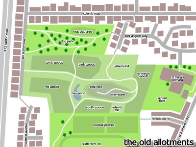
About 10 years ago Great Yarmouth Borough Council abandonned a patch of allotments in Gorleston close to where i live in Gret Yarmouth. As such they became overgrown and a fantastic place for games of manhunt and for me and my friends to go and explore (kiddy I know but fun). They had dug a massive hole in the middle of the place for soil to build the embankment for the A12 road and so there is a huge ravine in the middle.
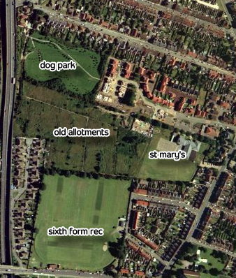
Most of the area was turned into woods by the council and the rest is long grass and there is a pond made by a dip and lots of rain. Until now we just made up names or bits of the park and stuff like that but I have actually bothtered to make a map of the area which was previously unmapped. Next time I go there I will take some photos of the place but you get the idea. It is mostly from memory and 10 year-old aerial images so it's not perfect.
Most of the area was turned into woods by the council and the rest is long grass and there is a pond made by a dip and lots of rain. Until now we just made up names or bits of the park and stuff like that but I have actually bothtered to make a map of the area which was previously unmapped. Next time I go there I will take some photos of the place but you get the idea. It is mostly from memory and 10 year-old aerial images so it's not perfect.
allotmap.jpg

The map I made using PhotoImpact http://i185.photobucket.com/albums/x209/gingerblokey3/allotmap.jpg link for full size
4 vote(s)
Terms
(none yet)2 comment(s)
posted by Not Here No More on December 31st, 2007 10:06 AM
Extremities of coolness and good mapping. Just wondering, is the ravine still there? I cannot tell from the picture.


Your maps are awesome!