


Walking by The Found Walrus, Waldo Cheerio
September 11th, 2008 10:12 PM / Location: 48.858644,-123.4598We suggest you read our praxes in the order above, although for all we know it may be more fun completely in reverse. In any case, please enjoy the musical backdrop for each, chosen from among those songs we sang during the 25 hour period as appropriate to the task.
This was the most challenging and painful task I've done, and the one I was most pleased about afterwards. I really like SF0 tasks that get me to do something I didn't think I could do. Walking 25 miles, for a couple of Los Angelinos, even reasonably athletic Los Angelinos, definitely falls into that category. Walking 25 miles linked together and relying on the generosity of others for sustenance felt epic.
We happen to be on a remote Canadian island off Vancouver. This is so much more suited to Walking than our native Los Angeles. We chose the most straightforward route which happened to be almost exactly 25 miles - from Long Harbor (where we were staying) to the town of Ganges, then bisecting the island (over hill and dale) to the town of Fulford, then reversing the entire route. The walk was almost entirely along main roads, which ensured we would (probably) not get lost, and handily brought us to the towns, which were necessary sources of free food. The only undesirable quality to our proposed hike was that we gained and lost a lot of altitude twice.
Google Map
8:00 pm: We begin Free Food and Never Let Go.
8:00 am: Attempted to wake up Waldo.
8:45 am: We left the house where we are staying, armed with two Ziploc bags, a map, a pen, a flashlight, blue tape, sunscreen a large bottle of water, spare contacts, phone, $40 Canadian, and for reasons still obscure to me, an ancient copy of the Onion.


9:05 am: We paused to pick blackberries to aid in Free Food efforts.

10:30 am: With a bulging bag of gently leaking blackberries, we reached Ganges, and the Walrus was delighted to find she was well known in this town:

10:45 am: A diversion to swap our free blackberries for sandwiches in the heart of Ganges: the 'illag Center (sounds Welsh, dunnit?)

11:00 am: Buoyed by our sandwiches, we left Ganges.

This is the hottest, steepest part of the day, climbing doggedly up the path towards Fulford. Waldo had his scarf and hat on at one point and a biker passing us turned and shouted, “Hey! Waldo!” which pleased everyone concerned. We also discovered how to take pictures of each other without breaking contact. It’s to do with feet.

12:00 pm: We got through the heavy climbing part and enter Phase 2: wandering around the mountainous highlands. My favorite thing to find here was a sign saying “Organic Golf Course” and pointing into a bog.

1:00 pm: We ran out of water but apparently locate Baggins.

1:30: We have descended from the highlands and enter Phase 3: The Bulge. (See map). It was still Lawrence-of-Arabia hot and we were very thirsty. We visited a winery for free samples and to fill our water bottle.

2:05: We were still on the bloody Bulge. Apparently it is larger than it looked on the map. We passed a pair of hikers and asked them where they’ve walked from. Five kilometers from Fulford, they explained, with evident pride. We one-upped them a little by explaining we’d walked from Ganges. They obviously thought we’re insane, but told us it’s about another twenty minutes to Fulford. As they walked away, I distinctly heard the man say to the woman, “Yikes!”

3:00 pm: After another long hike we reached the diminutive town of Fulford: a coffee shop, an eccentric thrift store, and a ferry terminal. The sign was at first terribly misleading!


We headed to the coffee shop, told our story, and were again given free food by the island's generous inhabitants. We did have to persuade the coffee shop guy of our honesty. He insisted that we could not have walked from Ganges and must have hitchhiked. And we filled our water bottle again. A lot of signs in Fulford seem to have been vandalized in some way.

3:30 pm: We set out from Fulford back to Ganges. The trip was half done and it had taken us six hours and forty-five minutes, though a decent part of that was spent foraging. Now there was really nothing to do but walk. My feet were really starting to complain quite stridently, but at least it was cooler.

6:00 pm: By this time the sun was starting to get quite low and we had entered the mountainous Phase 2, finally having pushed our way through the Bulge. We stopped on a handy log and ate our remaining food.

The problem, for me at least, was the feet. They seemed to have acquired much more delegates than usual in the crowded darkened chamber of my mind, and with a large contingent of legs, got up and began attempting a filibuster to prevent the motion of moving forward. A few renegade back delegates joined them, and the group attempted to, well, put their feet down to prevent me continuing the walk. They were overruled, but only just.
7:00 pm: After a hellish hour on aching feet we reached Ganges.

It was getting quite dark and large clouds were gathering overhead. We rested for a few minutes in the town park, and visited another storeowner we knew to exchange tales of what we were doing for a full waterbottle and free food.

We saw that a psychiatrist has a singularly charming sign

and also a message of hope on a local circuit breaker panel.

8:00 pm: The last two hours of our journey are not worth recounting. They were painful. They were unpleasant. They were, above all else, damp. One thing cheering occurred. While we were walking down Long Harbour Road, a smallish car made a turn off the road in front of us, and a woman of about seventy got out.

“I saw you on the way to Fulford!” she said, by way of introduction. “And then coming back! My friend and I recognized you by your heights, but we didn’t think it could be you because you couldn’t have walked that far. What were you doing?”
(Recognizing us by our heights made sense. Waldo is 6’3’’. I am 5’2’’.) We explained our journey. She listened, nodded, and explained she was very impressed. She also gave us the very welcome news that we were close to the next turning.
After that the light really gave out. We had brought a flashlight but never exactly had to use it. To keep our spirits up and try to quiet our yelling feet, Waldo and I tried singing: “Piazza”, “Handlebars”, and “500 Miles.” It says much for how tired we were that this was actually effective. Waldo is the very worst singer I know. I am only marginally better.
9:00 pm: Home after a 12-hour marathon.
We had hoped to be home by eight in order to have completed all three tasks in twenty-four hours, but it didn’t happen. So we extended Free Food and Never Let Go by an extra hour for 25-hour tasking.
Showers! Not standing up, as much as possible!
A Question of Distance
It was brought to our attention that the google maps presentation of our route only works out to 24.9 miles, and so we are force to account for the "missing" tenth of a mile.
The first thought we had was that on foot we had to cross the road a lot to avoid blind corners, as we were only on a partitioned walkway for 15 feet on the entire trip:
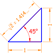
With a few calculations and rough measurements, we saw we only needed to find 20 places on the trip where we were forced to cross the road. Then again, not every crossing of the road was quite so direct as this. If on average we crossed the road at a 45 degree angle we only added 41.4% of the distance across the road to our journey. Now we would need at least 48 road crossings identified to boost our distance travelled by that elusive tenth of a mile. There was no way we crossed the road every half-mile, so it was back to the drawing boards, or face eternal flagnation.
A friend of ours who bikes recreationally then pointed out a great flaw in our documentation: elevation! Google-maps is plotting distances as though the world were flat, when in fact we knew (quite bitterly) that there were some significant hills we had conquered that day. As it turns out, the highest elevation we made it to was just over 450ft. above sea level, and just like our problem with crossing roads, it wasn't as if we walked on flat ground for 24.9 miles then went 0.1 miles straight up. We were not just going to let another triangle get in the way of our victory (especially not a triangle defending hills), so we took out the heavy computer science.
With some careful plotting, we were able to see just how much conquering was done of said hills, and how much distance we actually travelled:
http://www.gmap-pedometer.com/?r=2234883
Bam. Mileage verified. Suck it Hills.
The Road

goes ever on and on down from the door where it begun
Equipment

Of the electronic variety: cell phone, cameras.
For Emergencies Only

We did hope to get home before dark. In the end, we didn't - but we did make it to a stretch of road we knew well enough not to need a flashlight.
Stationary

Pad of paper for notes, pens, maps, sticky-notes. Why the blue tape? Why indeed.
Backups

Spare batteries for the camera bearing strange messages.
Why?

We carried this newspaper twenty-five miles, up and down hills, through hunger and tiredness, and it doesn't seem remotely grateful. It isn't even particularly funny or current for the Onion.
Sun Protection

UV Protection and polarized loose-knit scarves. Never leave home without them.
H2O

We refilled this about four times.
Smell that Glacier!

Nothing beats the smell of _Canadian_ Glacier.
Waldo's Pockets

Just for kicks, this is what he was carrying in his back pockets. Kleenex, a Benadryl, OK. Instruction sheet to a cock ring? Little stranger. (It was from Security Tester - we still hadn't found somewhere to throw away our props)
And...

a Ziplock Bag for blackberries, labeled helpfully.
The Bag

It didn't contain _all_ of SFZERO.org mind you, just a little.
Abandoned

It may not look it, but this rather elegant car was abandoned by the side of the road - engine gutted, seats removed. I wanted to adopt it. (Waldo doubted his backpack was large enough.)
Heading into Ganges

The roads on this island had a very sport-car-commercial feel to them. Zoom zoom we did not.
Stone Walrus

Apparently the Walrus' fame precedes her. Judging by the look of the building it preceded her by several decades.
Welsh!?!?

Most of the V and e from "Village" have been lost, leaving the 'illag Center sounding eccentric and faintly Welsh. Treat with Caution.
Waiting for the bus

These two people asked us if they could have a "toonie" which is a two-dollar canadian coin, for the bus. We obliged in return for a photo, but the guy almost made it out of the frame.
Leaving Ganges

It was eight hours before we reentered it. We tried a few other shots, but they all came out blurry, and remarkably less interesting than the one with that guy in it.
Fabulous view

From our hike we could see several other BC islands. (Which were very difficult to photograph for the purposes of Never Let Go.)
Eccentric

We just liked this car.
A sign...

...but here is where it's pointing.

I wish I knew if this was some sort of island joke or an honest mistake. The golf sign points directly into a tract of wild and unaltered land. Extreme.
Gate

Pleasant gate. My kind of gate. Lazy.
Baggins

Underhill is in quotes. I really hope this person was referring to Frodo's pseudonym at the Prancing Pony Inn of Bree.
Seven Ravens

Mysteriously, this place advertised itself as a "tree nursery" and had an elegantly painted picture of a globe juxtaposed with a tree.
Mt. Maxwell

Looming. It does that.
Two Doubtful Hikers

These guys were very proud of having hiked the 5 Km from Fulford. I felt a bit guilty with our rejoinder of about 20 Km from Ganges and counting.
Step Two: ? / Step Three: Profit!

The journey of one thousand miles begins with a single step; and absurdly complex and subjective first step that may require years of therapy.
The Fulford Community Hall

in all its majesty. In September. It isn't even close to Boxing Day!
All Mixed Up

By our calculations Ganges was a good deal further than 13KM away from the sign at this point. Our faith in the surveyors of this island would (unlike the topography) only go downhill from here.
Cruel Sign

This sign was at first cruelly misleading - it read initially as Fulford 8 km away.
Relief

0.8 Km. Phew. This time the Hoodlums were constructively protesting.
Vandalism

It would appear that the residents of Fulford like altering signs. "All Ferry Traffic to Stay Right" became "All Ferry Traffic to Stay High". I am really liking these hoodlums.
Direct and to the point

We must sell our husbands! I would be excited if someone sold a forgery through this site (hint hint).
View of Fulford

It's pretty small.
Dogwalker

with strangely color-coordinated shorts and hat.
The Only Sidewalk

In 25 miles, this was the only time we actually walked on a designated sidewalk. I suppose this might count as discriminating against sidewalks, except there were no sidewalks for us to discriminate against.
Amphibious vehicle

Straight out of 007, except very old. I doubt the sea-to-air missles even still heat-seek accurately.
Clouds gathering

This is Mount Tuam, the highest mountain on the island. Mt. Maxwell does outdo Tuam in terms of both view and impressiveness, though.
Disturbing sign

We are wandering around in the highlands (having reconquered the bulge) - how can Ganges still be 14 km off? (Please note, we came across this sign on the return trip, several km past the sign claiming Ganges was 13km away. And no, Ganges is not several km across; the visitor centre is perhaps 100m from the edge of town. Either edge.)
First drops at 15 Km

Several times the sky (which loomed larger in that Great White North than I am accustomed to back home) threatened to dampen our spirits, but never seemed to muster more than enough drops to remind us of the heat.
Perspective

Just to give you an idea of the sort of country we were walking through.
Eccentric

Waldo asked this fellow, who was wearing a fishnet shirt, if he could take his picture. The guy declined, so Waldo rather unsportingly took a shot as he walked away. (Hey, Toonie Bus Guy didn't even get fair warning first.)
Seven Ravens

from the other side the purpose of this establishment became much clearer. I just wish we didn't wait four hours before looking at it from the other side.
Groan-worthy

So many hills. So little feet.
?????

What? This feels like the pictogram equivalent of Engrish.
Dinner

Broken Tree

After ten hours of mostly trees, we came upon a tree which had fallen so suddenly, two branches connected by a thing strip of bark had been left behind, suspended fifteen feet off the ground. Peering through the leaves, you could see another tree locking branches with the defiant and still green-leaved branches.
OOPS

I liked this sign. I really did.
Incline

The odd thing was that the actual % incline was not specified. Solve for X.
Ganges Again

A very welcome sight indeed.
Resting

We paused for a while in the town park.
Watching Children

The local wildlife also enjoys the park.
Appealing Sign

Not only does it say "hours erratic," but it also says " 'phone" with an apostrophe - as though it's still ghosh to say "phone" without the preceding "tele".
Graffiti'd Dustbin

Not the place to find a message like this. It was encouraging.
The Fishery

We liked the sign. What can I say?
Feet

At this point a fairly large contingent body had put its foot down in protest. They were up in arms, throwing their weight around, demanding the matter at hand be laid to rest. Thankfully they were too poorly organized to decide whether a filibuster or a walk-out was afoot.
Sunset

If God exists, s/he has terrible taste. Who would use BOTH flame orange and bubblegum pink to paint a sky?
Incredulous Bystander

This rather nice woman had seen us walking twice: to and from Fulford.
Almost there

Here we turned. It was dark. Couldn't go on documenting much longer. Sang for comfort. If you could call it singing.
Raining

Between the increasing darkness, damp, and shivering, the pictures got a bit fuzzy.
Destination

The welcoming yellow lights of home, and the white light of flashlights from those who came to meet us. (Felt like the end of a Strange Encounters movie, where rejoining humans seems strange and alien to the survivor after their ordeal changed them so.)
Filthy Feet

Apparently the Walrus wears worse socks than Waldo, as judged by the condition of her toes. Hobbit feet know.
The Emu

The Walrus makes a friend! (Strictly speaking, this isn't part of the praxis, but still necessary.)
25 Miles is over, but...

We still had to walk a considerable hike down to the boat where we slept.
We headed down...

and quickly pavement ended. To our sore feet, the damp earth was a relief.
...and down.

I wanted to crawl. These photos are taken from the next morning, out of necessity. Physical necessity.
Helpful Sign

It is true. The path is slippery. Wx.
Each step

Was surprisingly agonizing. Apparently my feet were under the impression they had finally won, and did not take well at all to this reversal in status.
Long Staircase

Out of habit, we held hands. This was likely for the best, as we both nearly fell several times.
Nearly there...

The stairs were treacherous and irregular after all.
heading downward still

To the beach.

Don't ask me why the plastic fork. The final incomprehensible thing we saw that day and we could hardly muster a whimper.
Destination

The dock tower, leading to the long gangway out to the boat - where sleep is located. The feet win at last.
Walk500Miles.mp3
This song really is not the same without the accent and drums. Nonetheless, we "sang" this in increasingly fragmented bursts and starts the whole trip back from Fulford.
26 vote(s)
- Tøm
- Not Here No More
- Spidere
- Lincøln
- Peter Garnett
- nallox V
- done
- teucer
- Evil Sugar
- saille is planting praxis
- susy derkins
- Jellybean of Thark
- Myrna Minx
- Darkaardvark
- Dopey
- Absurdum
- Ben Yamiin
- Optical Dave
- Sombrero Guy
- Icarus
- GYØ Vicki
- Minch
- zer0gee
- Loki
- Nathan Dean
- gh◌st ᵰⱥ₥ing
Favorite of:
Terms
multitasking, sign, prove, sleep, mathematics, multiday, vandalism7 comment(s)

Towards the sake of proof, I very carefully mapped out our entire route, searching for every fraction of a mile. The map shows our trip up and down Lee road for the winery for instance (mile 9 on the pedometer), and I had no way to prove how long the boat path was. Besides, we felt the need to show our support for the Down With Hills movement anyway after that slog, believe you me.

i wish i could vote for each one of these more than once....

I really like your sign hunting/fishing. And the old lady stopping. Wow.


READ THIS! This is positively amazing. Don't let it get buried.
Congratulations on this feat. Now to read the other two.

Vote for overall awesomeness as well as:
1) being recognized by height
2) "suck it hills"
Surely the walk down to the boat and in and out of every store and winery made up the missing .1 miles, and all of the road crossing, and height adjustments were unnecessary?