


25 + 130 points
Misuse of Maps by Dela Dejavoo
April 3rd, 2008 6:41 AM
Mat Defiler and Dela Dejavoo embarked on the task of navigating our fair city with the following map:
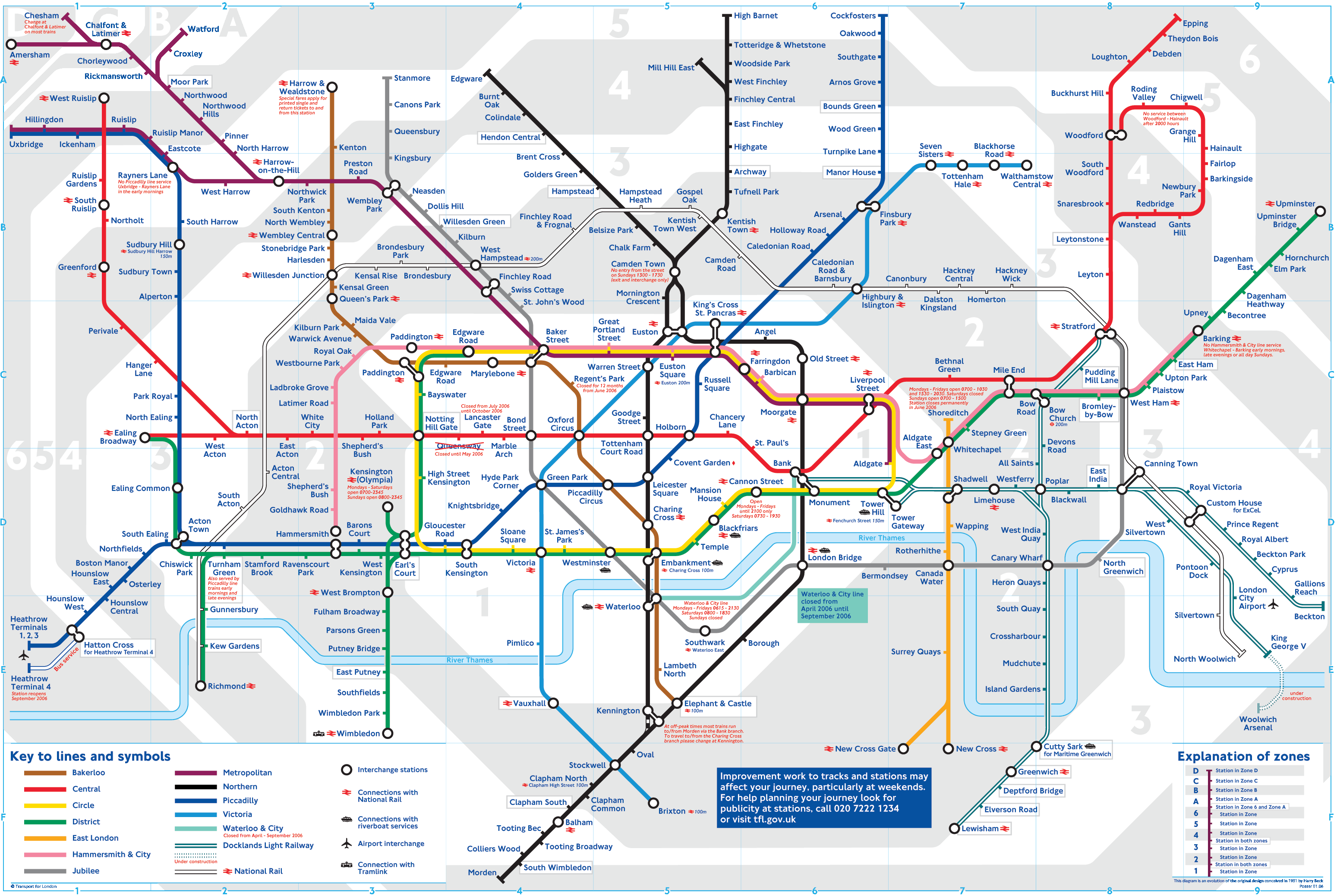
And also the subway map of the same city, which you can see here, viewed upside down.

You can view it right side up at the following link: http://www.gothamcityrail.com/map.htm
We chose to meet at "The Narrows" stop, as it was the stop where both the Orange and the Aqua lines meet. Since the Defiler lives on the Orange line and the Dejavoo lives on the Aqua line (mysteriously renamed the "blue line" according to the many signs we saw), we thought that would be our best shot. We planned to meet up and try and find a good place to eat. According to the subway map, The Narrows stop was closed, but we found it to be quite open.
Here we are sitting on the floor of said station examining our maps:

Dela Corresponding the Subway Map with the Street Map.
Mat, having rudely ripped the maps out of Dela's hand, continues comparing maps.


With a little work we figured out where we were in relation to the rest of the city. The street map had no street names, but did have a good list of neighborhoods and important landmarks noted with numbers on the map. The Dejavoo suggested, in her infinite wisdom, that Old Gotham(7), particularly the areas near Crime Alley(1) would be a good place to look for food. The center of town is never good for dinner because things shut down. And the areas further downtown, like the clocktower(38), and Cathedral Square(42) sounded likely to be touristy, which meant expensive food and lots of steak places and stuff like that. No place for thrifty vegetarians. Old Gotham, however, promised to be the seedier end of town, and we were in the mood for some cheap ethnic nibbles. We decided we'd travel the one train stop on the Aqua Line to the Prosper Street station where we would transfer to the Red Line. From there it would be 9 stops to the Fattore stop which, according to our careful cartographic comparisons, would land us smack in the middle of Old Gotham, aka "Tasty Vittles-Ville".
We walked toward the Aqua Line stop. Note here the odd renaming of the Aqua Line to the "blue line".

Arriving on our first train platform of the evening, we saw a sign which certainly must have been intended just for us:

When we got to the next stop over, we found that the connection to the Red line was closed, so we had to surface onto the streets of the center of town to find an entrance to the red line.

We finally found an entrance, but as you can see from the sign to the left of the Defiler, the station was closed. So we headed to the next station south, which put us 10 stops away from our destination.


So, we diligently counted our train stops as we trekked forward toward the ever elusive Old City. Mind you, while the street map listed Old City, the subway map merely had the whole area blocked out as "Uptown". We figured Old City was likely a sub-neighborhood.
There was a little confusion when we got to the Addison stop, which was unnamed on the map. We clearly saw a large Stadium from the train windows, even though the "Gotham Stadium" stop was another 2 stops away. Well, we perservered.
We got off on what promised to be "Fattore", though the platform signs stated "Sheridan". Looking out at the views from the platform, however, we were quite sure we'd made it to Old Gotham and the seedy neighborhood which promised to feature "Crime Alley", where the Wayne's were purported to have been killed.


After getting off of the train. we decided to walk the several blocks northward towards the famous alleyway, and keep our eyes peeled for tasty snacks on the way. Fortunately the Dejavoo had her compass.

And, not 2 blocks due north we began seeing evidence that we had found the right neighborhood:
 You can't read this so good, but it says "Nick's Uptown". Aha, we were Uptown, just like the subway map said. We kept walking north and found more evidence of being uptown, as well as other interesting sights.


The Streets began to narrow. Could it be we'd gotten close to our secondary destination? Yes yes, it seemed we'd found crime alley!


It got darker and dirtier and more full of scary crevasses the further we walked. Indeed it was not hard to believe that some terrible villain would choose this as an ideal location to kill Batman's folks.
Then, just as we exited the alley, Dela hollered "Holy large theater which wouldn't let the roller girls play there". Indeed, there was a large theatre just the other side of the alley. Weren't the Waynes leaving the theatre just before they met their unholy demise?


We'd found our alley to be sure. But in our excitement about looking for the landmark, we'd forgotten about the food! We turned the corner and alas, delicious ethiopian food awaited us at "Demera". Not as seedy as we'd hoped, but very delicious. Based on the decor and the dress of some of the restaurant's patrons, we wondered if the area around Crime Alley had not gotten a bit gentrified.

Our bellies full, we decided to head due west, as the map promised a harbor nearby. We walked 7 or 8 blocks before we found the water, and there was no harbor there, only the open sea. So we figured we'd veered a little further south than our mark. No matter, we stopped to enjoy the breezy vista before walking back to gentrified seedy-ville.


And once there, we noticed there was a stop near our restaurant. We got on it, assuming it would be the yellow line at Farrow or South Farrow. In truth it seemed to be a Red Line stop. No matter. We were tired, so we headed home and called it a night.
Below is the retouched map of our entire adventure.
The Orange, Aqua, and Red lines are superimposed in their proper colors.
Our path is demarkated by the pink line with arrows, the solid part being us on foot and the dotted part being us on the train.
I tried to write in "The Narrows" subway stop, but it is a little hard to read. The rest of the stops are merely marked with yellow dots.
The green writing at the top right of the map are the names of streets i recorded walking back from the water. Since there were no street names on the map, we figured we'd add them. That way, someone might find this map even more useful than did we!

We are considering returning to the various Aqua line stations with appropriate signs to place over the erroneous "blue Line" signs. The color of the signs themselves are so obviously Aqua!
And also the subway map of the same city, which you can see here, viewed upside down.
You can view it right side up at the following link: http://www.gothamcityrail.com/map.htm
We chose to meet at "The Narrows" stop, as it was the stop where both the Orange and the Aqua lines meet. Since the Defiler lives on the Orange line and the Dejavoo lives on the Aqua line (mysteriously renamed the "blue line" according to the many signs we saw), we thought that would be our best shot. We planned to meet up and try and find a good place to eat. According to the subway map, The Narrows stop was closed, but we found it to be quite open.
Here we are sitting on the floor of said station examining our maps:
Dela Corresponding the Subway Map with the Street Map.
Mat, having rudely ripped the maps out of Dela's hand, continues comparing maps.
With a little work we figured out where we were in relation to the rest of the city. The street map had no street names, but did have a good list of neighborhoods and important landmarks noted with numbers on the map. The Dejavoo suggested, in her infinite wisdom, that Old Gotham(7), particularly the areas near Crime Alley(1) would be a good place to look for food. The center of town is never good for dinner because things shut down. And the areas further downtown, like the clocktower(38), and Cathedral Square(42) sounded likely to be touristy, which meant expensive food and lots of steak places and stuff like that. No place for thrifty vegetarians. Old Gotham, however, promised to be the seedier end of town, and we were in the mood for some cheap ethnic nibbles. We decided we'd travel the one train stop on the Aqua Line to the Prosper Street station where we would transfer to the Red Line. From there it would be 9 stops to the Fattore stop which, according to our careful cartographic comparisons, would land us smack in the middle of Old Gotham, aka "Tasty Vittles-Ville".
We walked toward the Aqua Line stop. Note here the odd renaming of the Aqua Line to the "blue line".
Arriving on our first train platform of the evening, we saw a sign which certainly must have been intended just for us:
When we got to the next stop over, we found that the connection to the Red line was closed, so we had to surface onto the streets of the center of town to find an entrance to the red line.
We finally found an entrance, but as you can see from the sign to the left of the Defiler, the station was closed. So we headed to the next station south, which put us 10 stops away from our destination.
So, we diligently counted our train stops as we trekked forward toward the ever elusive Old City. Mind you, while the street map listed Old City, the subway map merely had the whole area blocked out as "Uptown". We figured Old City was likely a sub-neighborhood.
There was a little confusion when we got to the Addison stop, which was unnamed on the map. We clearly saw a large Stadium from the train windows, even though the "Gotham Stadium" stop was another 2 stops away. Well, we perservered.
We got off on what promised to be "Fattore", though the platform signs stated "Sheridan". Looking out at the views from the platform, however, we were quite sure we'd made it to Old Gotham and the seedy neighborhood which promised to feature "Crime Alley", where the Wayne's were purported to have been killed.
After getting off of the train. we decided to walk the several blocks northward towards the famous alleyway, and keep our eyes peeled for tasty snacks on the way. Fortunately the Dejavoo had her compass.
And, not 2 blocks due north we began seeing evidence that we had found the right neighborhood:
You can't read this so good, but it says "Nick's Uptown". Aha, we were Uptown, just like the subway map said. We kept walking north and found more evidence of being uptown, as well as other interesting sights.The Streets began to narrow. Could it be we'd gotten close to our secondary destination? Yes yes, it seemed we'd found crime alley!
It got darker and dirtier and more full of scary crevasses the further we walked. Indeed it was not hard to believe that some terrible villain would choose this as an ideal location to kill Batman's folks.
Then, just as we exited the alley, Dela hollered "Holy large theater which wouldn't let the roller girls play there". Indeed, there was a large theatre just the other side of the alley. Weren't the Waynes leaving the theatre just before they met their unholy demise?
We'd found our alley to be sure. But in our excitement about looking for the landmark, we'd forgotten about the food! We turned the corner and alas, delicious ethiopian food awaited us at "Demera". Not as seedy as we'd hoped, but very delicious. Based on the decor and the dress of some of the restaurant's patrons, we wondered if the area around Crime Alley had not gotten a bit gentrified.
Our bellies full, we decided to head due west, as the map promised a harbor nearby. We walked 7 or 8 blocks before we found the water, and there was no harbor there, only the open sea. So we figured we'd veered a little further south than our mark. No matter, we stopped to enjoy the breezy vista before walking back to gentrified seedy-ville.
And once there, we noticed there was a stop near our restaurant. We got on it, assuming it would be the yellow line at Farrow or South Farrow. In truth it seemed to be a Red Line stop. No matter. We were tired, so we headed home and called it a night.
Below is the retouched map of our entire adventure.
The Orange, Aqua, and Red lines are superimposed in their proper colors.
Our path is demarkated by the pink line with arrows, the solid part being us on foot and the dotted part being us on the train.
I tried to write in "The Narrows" subway stop, but it is a little hard to read. The rest of the stops are merely marked with yellow dots.
The green writing at the top right of the map are the names of streets i recorded walking back from the water. Since there were no street names on the map, we figured we'd add them. That way, someone might find this map even more useful than did we!
We are considering returning to the various Aqua line stations with appropriate signs to place over the erroneous "blue Line" signs. The color of the signs themselves are so obviously Aqua!


26 vote(s)
- Sparrows Fall
- praximity
- Julian Muffinbot
- susy derkins
- Stu
- Lincøln
- Myrna Minx
- Adam
- Secret Agent
- Bex.
- Jellybean of Thark
- Gremlin
- Scarlett
- Loki
- teh Lolbrarian
- Sean Mahan
- Mr. O.
- meredithian
- High Countess Emily
- rehsamsevoL Lovesmasher
- Indy
- Voo
- zer0gee
- Dax Tran-Caffee
- Togashi Ni
- PsyDlocke
Favorite of:
Terms
foecake, chicago7 comment(s)
posted by susy derkins on April 3rd, 2008 10:16 AM

Looks great and I´m sure I missed several references.
posted by Lincøln on April 3rd, 2008 10:58 AM

So good.
So good.
So good.
So so good.
As you can see, I have a soft spot for this interpretation of this task.
posted by Secret Agent on April 3rd, 2008 12:55 PM

That's amazing. I felt lost, and then found, and I didn't even have to leave the couch!
posted by Bex. on April 3rd, 2008 1:57 PM

You actually made me nervious for you, going at night to crime ally where all those scary people hang out! I'm glad you found your landmarks and made it out safe and fed!

posted by Scienceguru on April 8th, 2008 12:21 PM

Well, it might have been a little more Gotham-like if you'd made it to the South Side of town.
No need for "gentrified seedyville" in Chicago. Plenty available of the real thing.
Then, just as we exited the alley, Dela hollered "Holy large theater which wouldn't let the roller girls play there". Indeed, there was a large theatre just the other side of the alley. Weren't the Waynes leaving the theatre just before they met their unholy demise?
Best. Ever.